|
Daniel Rojšek The western Visoki kras of Slovenia - A park ? | ||||||||||||||||||||||||
KEY WORDS: conservation of karst phenomena, regional park,
natural heritage and features, Visoki kras -
upland or high karst massifs, Republika Slovenija -
Republic of Slovenia, Europe. |
ABSTRACT |
Upland karst massifs of Banjšice, Trnovski gozd, Gora,
Javornik, Hrušica and Nanos are the most northwestern outgrowths
of the Dinaric orographic system. They are called Visoki kras in
the Slovene geographical literature. The Visoki kras eastern
upland karst massifs of Snežnik and Javorniki should be
protected together with Cerkniško jezero and Planinsko polje by
the law of Notranjski park (The Notranjska regional park). | The Trnovski gozd massif was proposed to be protected as national park in 1961, but the proposal was rejected. Three landscape parks Južni obronki Trnovskega gozda in Gore (Southern foot-hills of Trnovski gozd and Gora), Južni in zahodni obronki Nanosa (Southern and western foot-hills of Nanos) and Zgornja Idrijca (The upper Idrijca river) were proclaimed in last ten years. New procedure to prepare special groundwork for the regional park legislation started in the spring of 1994. In the article geographical characteristics of the Visoki kras region, natural features, endangerness and other reasons to protect the area are presented.
INTRODUCTION |
Slovenija is a karst land, the region of matični Kras - the
Mother or Classical Karst. In the country karstic drainage occurs
or predominates in 43 % of the area (7200 km2 limestones, 1600
km2 dolomites, I. Gams, 1974: p. 7, 233, 330). There is need to
protect karst areas in the country. | The high mountainous karst of the eastern Julian Alps, the karst in slopes of Logarska dolina and Robanov kot, the Golte massif, the Planinsko polje, the Rakov Škocjan karst valley, the Glinščica and the Lahinja fluvio-karst drainage basins, the Vremščica hill, Mašun in the Snežnik massif, Postojnski kras with the cave system, Škocjanski Kras with the cave system and the Velika voda - Reka karst canyon and few hundreds caves and cave systems are protected by laws or decrees in Slovenia. The most northwestern outgrowths of the huge Dinaric orographic system are called Visoki kras together with the massifs of Javorniki and Snežnik in the Slovene geographical literature. Three landscape parks and 38 units of natural heritage are proclaimed by decrees of communes Ajdovščina (1987) Idrija (1993), Nova Gorica (1985) and Postojna (1984). There is need to proclaim regional park in western Visoki kras by a law in the country.
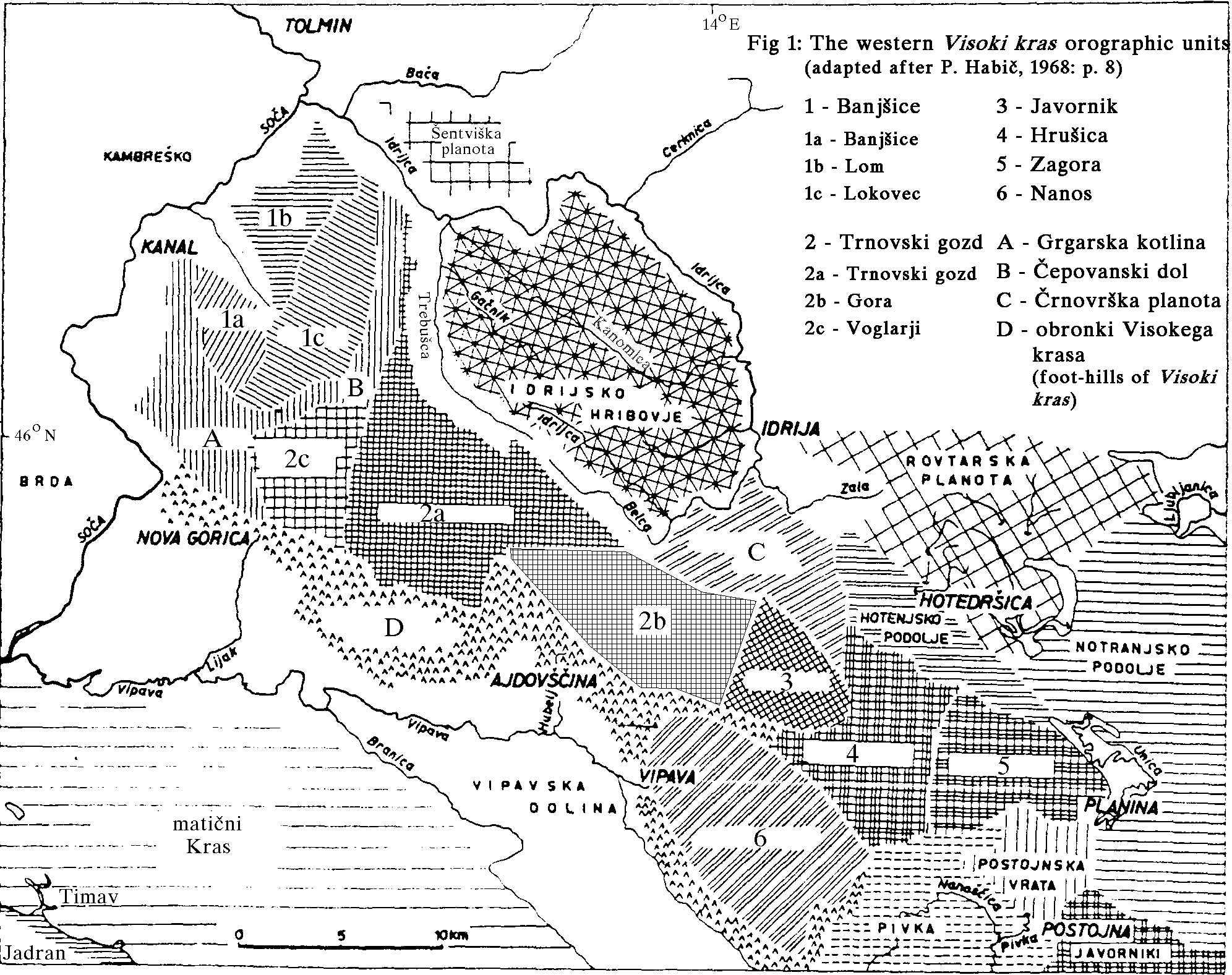
BASICAL GEOGRAPHICAL CHARACTERISTICS |
The treated Visoki kras lies in west Slovenia between
13o 36' 54'' and 14o 15' 16'' E longitude, 45o 45' 16'' and 46o
8' 17'' N latitude. Orographically it is divided in six upland
karst massifs: Banjšice, Trnovski gozd with Gora, Javornik,
Hrušica, Zagora and Nanos. The Čepovanski dol dry valley (one of
the biggest and well developed in Slovenia) has to be mentioned.
The valley divides Banjšice and Trnovski gozd
(Fig. 1).
Cretaceous, Jurassic and Triassic limestones with dolomites
dominate in Visoki kras
(Fig. 2).
There are different theories
about geomophogenesis of the area in the literature (P. Habič,
1968: p. 15-16). M. Herak (1987) interpreting the geomophogenesis
by pushing of Adriatic plate northwards where the Eocene flysh
of Vipavska dolina was underlain below the Mesozic rocks (mainly
limestones and dolomites). The Herak's theory is prefered by the
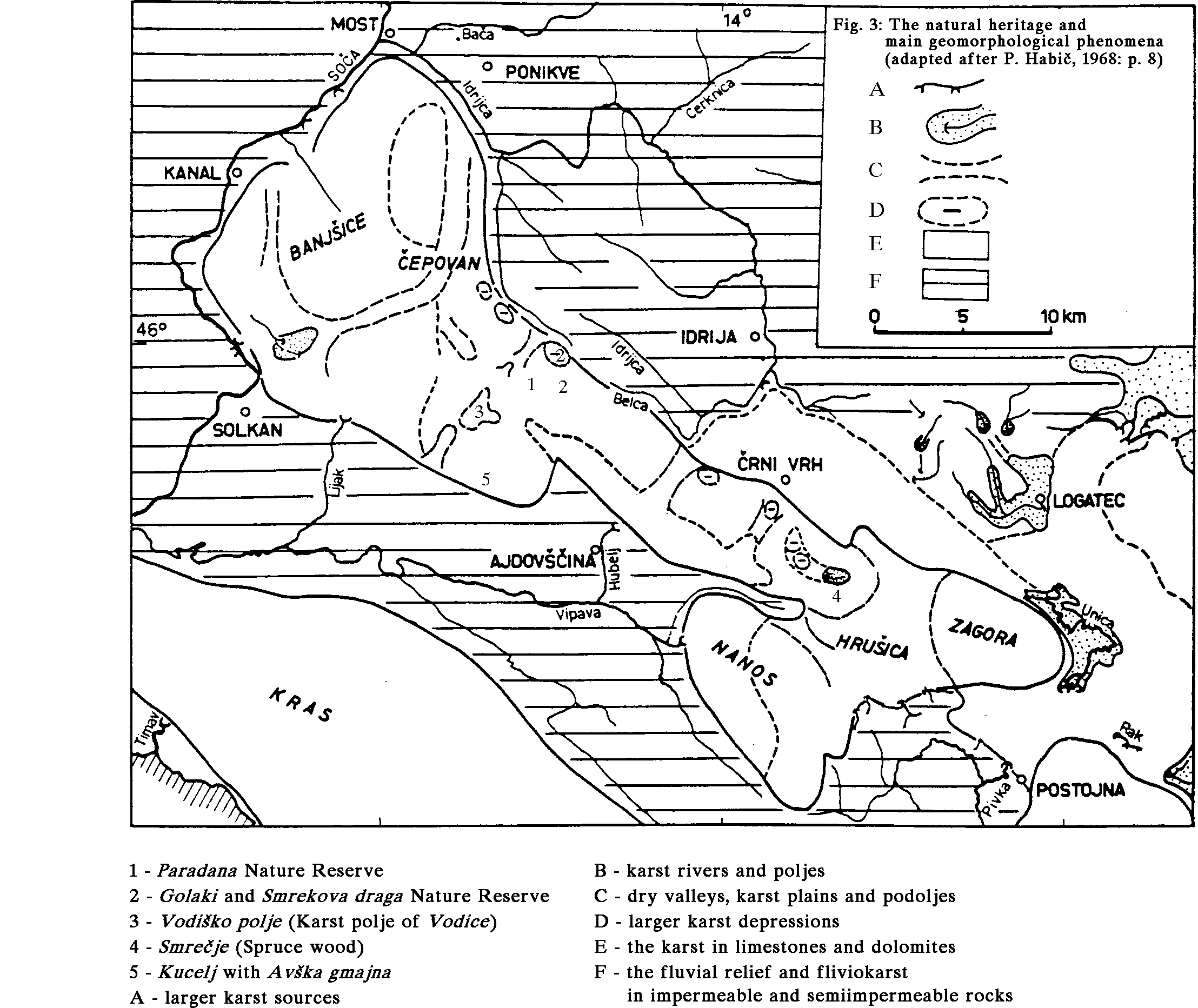
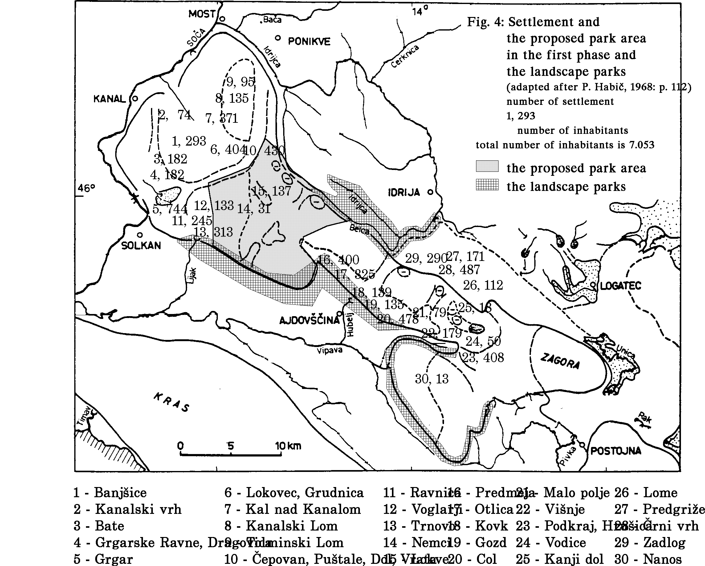
author of the paper. | The Visoki kras climate is transitive between the alpine and the continental on the northern side and submediterranean on the south. There are a lot of precipitations in the area. The wettest is the highest part of the Trnovski gozd massif with more than 3000 mm of long term average annual precipitation, there are more than 2000 mm of the precipitations in the other parts of the massif. The precipitation maximum occurs in autumn, but other seasons are wet, too. There is a lot of snow in winters. Heavy rainpours with more than 300 mm of daily precipitation are frequent in the Visoki kras. Among recent geomorphological processes is the corrosion in the first place. The highest parts were covered by glaciers in the Pleistocene. Many karst phenomena can be found in the area: karst poljes, dry valleys, glacio-karstic depressions, dolines, pothole dolines, karren, limestone pavements, caves and potholes, many of them with permanent snow and ice. Strong karst springs emerge at the foot-hills (Fig. 3). The area is covered with fir-beech forest (Abieti-fagetum dinaricum) and islands of spruce (Piceetum subalpinum dinaricum) and beech forests (Piceetum subalpinum dinaricum). Endemic (Primula carniolica* and x venusta*, Hladnikia pastinacifolia)*, alpine (Gentiana clusii, acaulis* and lutea*, Leontopodium alpinum, Viola pinnata, Primula auricula) and submediterranean (Anthyllis jacquinii, Genista holopetala, Quercus ilex*) plant species, which are growing in separat but relatively close places. The area is faunistic practically unresearched, although abundant wildlife is significant in the Visoki kras massif. The wildlife data originated from hunters. Zoological species as brown bear* (Ursus arctos), wolf* (Canis lupus), lynx (Lynx lynx), wild cat* (Felis silvestris), deer (Cervus elephus), Tetrao urogallus*, about 10 species of bats*, golden eagle* (Aquila chsryaetos) and others, which are frequent in the Central Europe stay or appear in the area. There were done some research in the karst underground and species as Proteus anguinus*, Leptodirus hochenwarti, Oryotus schmidti and others were found. One of the vantages to proclaim the regional park is sparse settlement of 30 villages and many solitary farms with total population of 7.053 inhabitants from census of 1991. Central part of the area is unpopulated (Fig. 4).
NATURAL HERITAGE |
The area belongs to four communes of Ajdovščina, Idrija, Nova
Gorica and Postojna. Prospectus inventories of natural heritage
in Ajdovščina and Nova Gorica communes were done (M. Gorkič, D.
Rojšek, M. Sušnik, 1985 and 1988, D. Rojšek, 1992) and 184 units
of natural heritage were inventoried. The units belong to all
five groups of natural heritage (D. Rojšek, in print). The most
units pertain of the first group (some elements of relief or
geological and geomorphological heritage) where bigger karst
caverns dominate with 115 representatives.
Designations of many units of the area are published (D.
Rojšek, 1992). Five units: the nature reserves Paradana and
Golaki with Smrekova draga, the high karst polje Vodice, the
glacio-karstic depression Smrečje and the mount Kucelj (1237 m)
with Avška gmajna (Fig. 3) are chosen to be shortly introduced.
|
Paradana Nature Reserve |
Not far from Lokve (the popular winter sports center for Nova
Gorica and Gorica - Gorizia) lies Paradana Nature Reserve
covering an area of 18 ha. It's name derives from the area under
Golaki (1495 m), the highest summit of Trnovski gozd. Within the
nature reserve are botanical and forestry reserves and natural
monuments: glaciokarst depression and Velika and Mala Ledena
jama (Big and Small Ice Cave). It has an extremely rich natural
heritage, one which could be classified as rare even on a
universal scale. | The most important point of interest of the reserve is the intermingling of superficial and underground karst with the remains of glacial activity and also temperature and vegetation inversions. At an altitude difference of a hundred meters the following belts occur (first described in 1906 by V. M. Beck): fir-beech ( Abieti - Fagetum dinaricum), spruce (Piceetum subalpinum dinaricum), willow-tree (Salicetum appendiculatae ), dwarf-trees and mountainous meadows, mosses, snow and permanent ice in the entrance to the cave system. Deeper inside the cave system the ice is no longer present; approximately every hundred meters the temperature rises by one degree Celsius. The Paradana cave system consists of three caves: Velika Ledena jama (385 m deep, 1550 m long; total length of the potholes 650 m); Mala Ledena jama, 40 m deep and 60 m long) and the so-called Jama pri Mali Ledeni jami (29 m deep and 125 m long), the connection among them has not yet been discovered. Morever, cavers have not yet discovered the bottom of the cave system. The variety of the different passages some covered by ice, others iceless, shafts, ox-bow passages and sharply turning channels with strong draughts is very interesting. The ice table fluctuation is considerable, sometimes the passages into iceless parts of the system are completely blocked. Once the ice was exported to Egypt, as the locals had produced some inventive technical devices which have unfortunately not been preserved. On the trees along the road and in the permanent ice remain parts of the old cable-way which was active in fifties when ice was still used for cooling the fruit from the area which was intended for export. The people from Lokve are rightly proud of Velika Ledena jama as it is an important part of their cultural heritage.
Golaki and Smrekova draga Nature Reserve |
The highest part of Trnovski gozd, named Golaki is a
protected nature reserve (forestry and botanical). Within the
nature reserve is the glaciokarst depression called Smrekova
draga. | Mali Golak (1495 m) is the highest peak of Trnovski gozd and one of rare Slovenian non-alpine summits reaching the secondary tree limit. The summit is covered by dwarf-pines (Pinetum mugi) and high mountainous grass (Caricetum firmae ). The results of glacial activity in this region are well preserved, Golaki was glaciated during the Pleistocene age. When there is nice weather there is an exceptional view from Golaki to near and wider countryside. Smrekova draga is one of the biggest glaciokarst depressions in Trnovski gozd. Its particularities are the temperature and vegetation inversions. In ground-plan the depression has an irregular oblong form, a 1.5 km long axis oriented in a Dinaric direction. Smrekova draga is 140 m deep, its bottom is 1110 m a.s.l. It's bottom and slopes are covered by rubble and vegetation distributed by vegetation belts. Plant succession is similar to the one in the Paradana Nature Reserve with the only exception of two very remarkable spruce (Piceetum) and dwarf pine (Mugetum) belts. The majority of the vast bottom is covered by peat mosses and dwarf-pines (Sphaguetum pinetosum mugi).
Vodiško Polje (Polje of Vodice) |
The karst area of Vodice developed on flysch in the middle of
various limestones. Springs and ponors are formed on contact of
permeable and impermeable rock. A small sinking stream flows
over the sediments at Polje's bottom, which is partly swampy and
periodically flooded. Higher parts are cultivated - there are
fields and meadows, and woods grow on the borders.
Northeastwards the area opens into a broad valley separated by
only a low pass. | The karst polje of Vodice is one of the highest Slovene karst poljes, lying 900m a.s.l..
Smrečje (Spruce Wood) |
Smrečje is a large glaciokarst depression of an irregular
shape, oriented southwest. It consists of three units: Mala and
Avška lazna, and Smrečje itself. | Due to natural karst processes the rim and the bottom of the depression are very dissected. The bottom is covered by huge sand deposits with dolines and intermediary hummocks. In Smrečje the temperature and vegetation inversions are well expressed. Beech-fir woodland (Abieti-fagetum dinaricum) changes into spruce wood (Luzulo albidae - Piceetum) according to the conditions. Among the rare plants we could mention Listera cordata, Galium saxatile and Gentiana kochii. The acidophilous Gentiana is growing in carbonate region, but in acidulous soil on sand deposits of Mala lazna. On the borders of Smrečje on Preval sites have been found of corals and Brachiopoda, some 65 millions years old.
Kucelj with Avška gmajna |
The mount Kucelj (1237 m) has at the north foot so-called
Avška gmajna. Variegated lithologic basis with unique
geomorphological phnenomena and mixture of alpine and
submediterranean botanical species are peculiarity of the area. | The mount is pyramidal shaped and withdrawn on the horizon of Vipava valley. The Eocene flysch in southern foot is followed by Quarternary rubble and Mesozoic rocks on the top. The Avška gmajna north foot spreads on karstificated Jurassic limestones. Dolines and intermediary hummocks with karren dominate amongst karst phenomena. Abundance of botanical species is reflected by number of species and by great number of single species specimens. It is amazing to admire thousands of high mountainus plants Primula auricula, Gentiana clusii, Viola pinnata and Leontopodium alpinum, just quarter of an hour walk from the road. Representatives of submediterranean (Anthyllis jacquinii, Genista holopetala) and endemic species Hladnikia pastinacifolia also grow in the area.
CONSERVATION OF THE AREA |
The procedure to proclaim national park in the Trnovski gozd
massif started in 1955. The proposal was submitted in 1961, but
it was rejected in 1962, because of Slovene ministry for
agriculture and forestry, Slovene ministry for common economy,
regional department for economy, the establishment for forest
economy and Slovene association of hunters reluctances. | Prospectus inventarisations of natural heritage in communes of Nova Gorica and Ajdovščina began in 1983 and in 1985. Proposals to proclaim natural monumants and reserves and two landscape parks (southern foot-hills of Trnovski gozd with Gora and eastern, southern and western foot-hills of Nanos, D. Rojšek, 1992: p. 174, 184) were prepared . Three decrees were promulgated in 1984, 1985 and 1987. In the northern foot-hills of Trnovski gozd landscape park Zgornja Idrijca (o.c.: p. 110-111) was proclaimed in 1993. Soft conservation regimes of the landscape parks and conservation of the protected spots do not protect the area satisfactory. New procedure to proclaim the regional park Trnovski gozd started in march 1994. Starting-points to proclaim the park: * meaning of Visoki kras from viewpoints of natural history (geology, physical geography, karstology, hydrogegraphy, hydrogeology, biology, forestry...) and other; * endangerness of nature and natural heritage by unsettled visits of numerous motorised tourists (motocross, crosscountry vehicles...) and by mass gathering of forest fruits; * the proclaimed landscape parks; * roles of locals and publicity in the procedure and after; * "Zavarovanje pragozdov in eventuelnega narodnega parka na Trnovski planoti" - the proposal for national park from 1961. Special basis for conservation of the Trnovski gozd will be prepared for the forest in the state possession in the area of 110 km2 in the first phase to avoid problems with a private property. The area is nearly unsettled, exist only two settlements Lokve and Nemci with 168 inhabitants. After successful function of the park the other parts of Visoki kras should be gradually proposed.
CONCLUSION |
There are many reasons to protect high karst in western
Slovenia. Meaning of Visoki kras from viewpoints of natural
history (geology, physical geography, karstology, hydrogegraphy,
hydrogeology, biology, forestry...) is together with endangerness
of nature and natural heritage by unsettled visits of numerous
motorised tourists (motocross, crosscountry vehicles...) and by
mass gathering of forest fruits in the first place. The
proclaimed landscape parks, roles of locals and publicity in the
procedure and after it and the proposal for national park from
1961 have to be mentioned, too. | First of all the regional plan of the area has to be replenished with the proposed regional park. Contemporary special basis for conservation of the Trnovski gozd should be prepared together with researching of "status zero" (ecological parameters, human impact on the karst geoecological system and similar).
REFERENCES |
V. M. Beck, 1906, Umkehrung der Pflanzenregionen in den
Dolinen des Karstes, Sitzungsber. K. Akad. Wiss. in Wien-Math.
naturw., Kl. Bd CVI, Wien. | I. Gams, 1974, Kras - Karst, p. 1-360, Slovenska matica, Ljubljana. P. Habič, 1968, Kraški svet med Idrijco in Vipavo - The karstic region between the Idrijca and Vipava rivers, p. 1-244, Slovenska akademija znanosti in umetnosti, Ljubljana. M. Herak, 1987, quotation in Vipavska dolina. M. Gorkič, D. Rojšek, M. Sušnik, 1985, Naravna dediščina v občini Nova Gorica, typwriting in archives of Zavod za varstvo naravne in kulturne dediščine Gorica v Novi Gorici, Nova Gorica. M. Gorkič, D. Rojšek, M. Sušnik, 1988, Naravna dediščina v občini Ajdovščina, typwriting in archives of Zavod za varstvo naravne in kulturne dediščine Gorica v Novi Gorici, Nova Gorica. A. Martinčič, 1992, Rdeči seznam ogroženih listnih mahov (Musci v Sloveniji - The Red List of Thretened mosses (Musci) in Slo¸ venia Varstvo narave, no. 18, p. 7-166, Zavod RS za varstvo naravne in kulturne dediščine, Ljubljana. Red Data Lists of plants --> T. Wraber, P. Skoberne, 1989 and A. Martinčič, 1992. Red Lists of Endangered Animal species in Slovenia, 1992, 21 articles by 24 authors, Varstvo narave, no. 17, p. 7-210, Zavod RS za varstvo naravne in kulturne dediščine, Ljubljana. D. Rojšek, 1992, The Natural Features of Posočje, p. 1-211, DZS d.d., Ljubljana. D. Rojšek, in print, Inventarisation of Natural Heritage, Acta carsologica, vol. 23, Ljubljana. T. Wraber, P. Skoberne, 1989, Rdeči seznam ogreoženih praprotnic in semenk SR Slovenije - The Red Data List of Thretened Vascular Plants in Socialistic Republic of Slovenia, Varstvo narave, no. 14-15, p. 7-429, Zavod RS za varstvo naravne in kulturne dediščine, Ljubljana. ____________ *marked species are inscribed in Red Data Lists (1989, 1992). FIGURES Fig. 1: The western Visoki kras orographic units Fig. 2: Geological survey map Fig. 3: Main geomorphological phenomena and natural heritage Fig. 4: Settlement and the proposed park area in the first phase |